Improving Green Infrastructure
in the Round Hill Conservation Area.
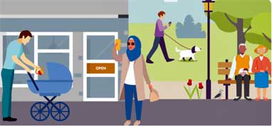
Round Hill is a densely-built Conservation Area with almost no public green space. As a result, streets, frontages, and small shared spaces play a vital role in supporting wildlife, improving air quality, and helping residents cope with hotter summers. The neighbourhood supports a high degree of wildlife, with records confirming over 180 bird species and the presence of protected bats, underlining its ecological importance within the city.
This community-led project will strengthen green infrastructure along the nature corridor that runs through Round Hill by planting new street trees, enhancing wildlife habitat, and supporting residents to grow wildflowers where they live.
Residents will see and feel the benefits day-to- day: cooler, greener streets; more birds and pollinators; improved air quality; and a neighbourhood that feels healthier and more resilient to climate change.
Dominic Furlong writes:
"I have submitted the Round Hill Society's proposal to the Better Brighton & Hove Fund / Neighbourhood CIL. I've attached the final documents which are available on The Council's website."
- an infographic of the proposal [PDF view here online]
Please comment on our proposal at https://yourvoice.brighton-hove.gov.uk/en-GB/ideas/improving-green-infrastructure-in-the-round-hill-conservation-area. You will be able to vote for it during the second phase of the consultation in Spring 2026..
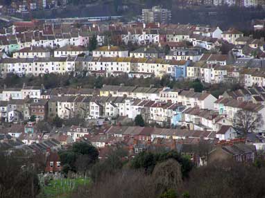
The South Downs Way Ahead Nature Improvement Area: note the green segment at the top of the picture beyond the five semi-detached 1860s villas and the green arc running across the centre of the picture. Further tree planting in Richmond Road will strengthen the Nature Improvement Area designation by greening the streetscape.
The South Downs Way Ahead Nature Improvement Area
as it runs through Round Hill
- Both Wakefield Road and Richmond Road (to the junction with Ashdown Road) are parts of the town corridor of the South Downs Way Ahead Nature Improvement Area, formally adopted into The Brighton & Hove City Plan Part 1 (March 2016). See policy CP10 Biodiversity (p181).
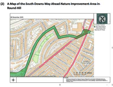
- The first East Sussex and Brighton & Hove Local Nature Recovery Strategy (LNRS) has now been drafted. It designates this same corridor as an Area That Could Become Important for Biodiversity (ACIB), and specifically as an “Area for Creating New Wildlife Corridors.”
- The former laundry drying fields between Richmond Road and Round Hill Crescent are newly identified as an ACIB area “where habitat could be increased in existing green spaces.”
Map of South Downs Way Ahead Nature Improvement Area:-
Area that Could Become Important for Biodiversity (ACIB) showing a longer section of the same corridor from Old Steine to Woodvale
This map illustrates that the project targets one of the few strategic nature-recovery opportunities in the ward.
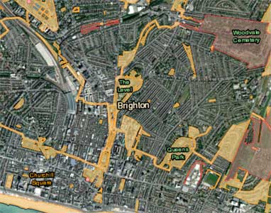
Aerial view of site on Google Earth
You can trace Brighton's longest greenway by clicking and dragging on the Google Earth map. Trace the "green ribbon" to the jack-knife junction of Wakefield Road and Upper Lewes Road. Then hop across the busy A270 into the generous pool of greenspace (bounded by Park Crescent and Union Road) proceeding to The Level. Then continue past St Peter's Church and Gloucester Place into the Victoria Gardens. Alternatively, head in the opposite direction tracing the green vista to the north side of Roundhill Crescent. There is a similarly generous gap at the south end of D'Aubigny Road, which allows public views into Woodvale (a continuation of this long greenway) up to Tenanty Down and the ridge near the Race Course.
Nature Improvement Areas
The South Downs Way Ahead Nature Improvement Area (NIA) — as referenced in The Brighton and Hove City Plan Part 1 (adopted March 2016) — is a landscape-scale nature conservation designation that covers Brighton & Hove’s Green Network and much of the surrounding downland. It was announced by the UK Government in February 2012 as one of the first NIAs.
Key points about the South Downs Way Ahead NIA
Purpose and Scope
It is a strategic, landscape-wide area designated to restore, enhance and connect wildlife habitats across an extensive area that includes urban fringe, downland and green spaces around Brighton & Hove.
The aim is to deliver significant improvements for wildlife and people through actions such as restoring priority habitats (notably chalk grassland), linking fragmented sites, and improving access to nature.
Role in Local Planning Policy
In the City Plan Part 1, the South Downs Way Ahead NIA forms the backbone of the city’s Green Network, and maps show its boundary in the plan’s policies map.
Policy CP10 (Biodiversity) specifically focuses on taking a strategic approach to biodiversity improvement within the NIA, encouraging development to contribute to habitat creation, restoration and connection.
CP10 Biodiversity
The council will develop programmes and strategies which aim to conserve, restore and enhance biodiversity and promote improved access to it through the following:
1. Working with neighbouring local authorities, contribute to the delivery of biodiversity improvements within the South Downs Way Ahead Nature Improvement Area (NIA), which incorporates parts of the urban area, the urban fringe, the seafront and surrounding downland. Within the NIA, a strategic approach to nature conservation enhancement will be taken, with the objectives of:
- linking and repairing habitats and nature conservation sites to achieve landscape scale improvements to biodiversity;
- conserving, restoring, recreating and managing priority habitats and protecting and recovering priority species populations to contribute to Local Biodiversity Action Plan targets;
- enabling people to have improved access to and understanding of local habitats and species; and
- ensuring development delivers measurable biodiversity improvements.
Landscape-Scale Conservation
NIAs like this one take a landscape-scale approach, meaning efforts aren’t confined to small isolated sites but aim to create connected habitats that support wildlife movement, increase resilience and enhance ecosystem services.
This includes urban wildlife corridors, chalk grassland restoration (critical for many rare species), and encouraging recreation and education.
Partnership and Delivery
Delivery involves local authorities and environmental partners working together (e.g., Sussex Wildlife Trust) to meet biodiversity targets and integrate nature enhancement into planning and development.
In summary, the South Downs Way Ahead Nature Improvement Area is a government-backed, landscape-scale conservation initiative embedded into Brighton & Hove’s planning framework to protect and restore biodiversity, connect habitats across the city and countryside, and guide sustainable development that enhances the natural environment.
This page was last updated by Ted on 26-Apr-2026