Richmond Road
After reading this page, try the Richmond Road quiz
SOURCE: proposed update for Round Hill's conservation character statement
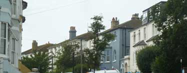
The road partly follows the alignment of the 1854 Roundhill Park masterplan. Large paired Villas are shown lining the north side. These date from the 1860s.
Writing in The Round HIll Reporter Issue 81 September 2020, Suzanne Hinton explains how Richmond Road got its name. When Charles II (1660-1685) had a son by Lady Louise de Penancoet de Keroualle he was not her husband. But illegitimacy should not be a barrier to the future prosperity of a son of the king, so Charles granted him an English dukedom (Richmond) and a Scottish one (Lennox). The second Duke of Richmond, Charles Lennox (1701-1750), was born on the English estate (Goodwood, near Chichester) and also received a third dukedom – in France this time – Duc d’Aubigny. Over a century after Charles Lennox’s death, the developers of Round Hill saw a sufficient connection to the Lennox family to plan roads named after their three principle estates - Richmond, Lennox and D’Aubigny.
STREETSCAPE (NORTH WEST SIDE)
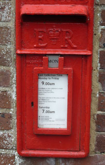
There is a rare wall letter box in Richmond Road bearing the royal cypher EVIIR (King Edward VII).
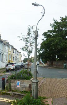
The cast iron street lamps date from the 1880s and were made as columns for gas lamps by a Brighton foundry. See Thematic survey of Street Lights. The street lights were later powered by BLEECO, the Brighton, Lancing and Eastbourne Electricity Company. The swan necks, cast by J Every of Lewes, were added in the 1930s.
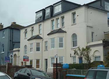
The six pairs of semi-detached villas on the west side of Richmond Road, now numbered 5-23, date from the 1860s and were allegedly built to house army officers from Preston Barracks. Land was purchased in 1856 by The Honourable Robert Bourke and Newnham Winstanley for their construction. Bourke’s father was the 5th Earl of Mayo and his elder brother acceded to become the 6th Earl.
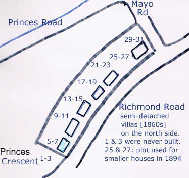
Villas 1-3 were never built, houses now occupying the site being numbered as part of Princes Crescent. Numbers 25 and 27 were also not built. The three houses currently on site and originally numbered 25, 27 and 27a were built in 1894.
The villas numbered 29 and 31 became part of the Mayo Laundry. No. 31 was demolished after World War II to accommodate extensions to the boiler room. No. 29 was also demolished when the laundry closed in 1984. The current Mayo Court flats took the place of the villas originally at 29 & 31 Villas 21-23 were knocked into one when William Fisher purchased the buildings from the Army and set up a golf ball recycling factory there in the 1920s.
A staffing level was maintained of about 30 employees until 1945. During the Second World War, the buildings were used for munitions work, but then continued as a golf ball factory until the 1970s.
After use by a rubber goods manufacturer and then as a carpentry workshop, in 1982 the buildings were converted back into housing to some 20 flats. All the villas have now been converted into flats and have suffered from a consequent loss of architectural detail including the insertion of uPVC windows and re-roofing in concrete tiles. However they do sit back slightly from the road, sometimes behind flint and brick walls, and this provides some garden space in the centre of the conservation area.
In keeping with the proportion of the villas, the back gardens are also generously sized and make a notable contribution to the verdant character of the conservation area, forming a green segment when viewed from Tenantry Down near Brighton Race Course. They are not visible from Richmond Road itself, but contribute to the visual amenity of several neighbouring properties.
STREETSCAPE (SOUTH EAST SIDE)
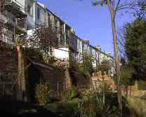
Some of the open spaces occupied by or attached to gardens on the south-east side of Richmond Road are also very generous. Several were once used by laundries as drying fields. Today they are havens for wildlife.
Richmond Road is part of the town corridor of the South Downs Way Ahead Nature Improvement Area. City Plan Policy CP10 Biodiversity (para. 4.133) confirms 'The South Downs Way Ahead Nature Improvement Area (NIA) includes all of the city's Green Network and much of the surrounding downland’. SPD11, Brighton and Hove City Council’s Supplementary Planning Document on Biodiversity and Nature Conservation aims to ensure that the Local Biodiversity Action Plan (LBAP) and the Brighton and Hove Green Network is fully integrated into the local planning process.' SPD11 confirms the green network includes 'land suitable for habitat creation to meet local, natural green space and LBAP targets.
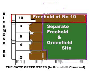
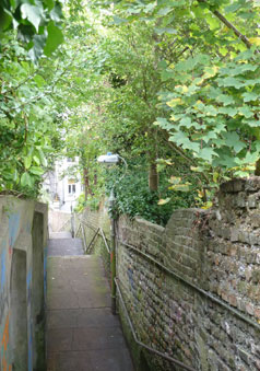
In the early 1890s, 10 Richmond Road, built as the end house in 1884, was a laundry owned by William and Sarah Tidey who later named their enterprise THE PRIMROSE LAUNDRY and in 1898 moved to 20 (now 22) Crescent Road. The separate freehold owned by 10 Richmond Road, formerly a drying field, extends to the Cats Creep, the steep flight of steps linking Richmond /Wakefield Roads at the top with Roundhill Crescent at the bottom. Nos. 2 to 8 Richmond Road, built by Burstow and Burstow, were added in 1897 once it was realised that Lennox Road was unviable. Shortly after that, Lennox Road was converted to what are now the Cats Creep steps. The gardens of 2 to 8 Richmond Road are truncated, but there is a separate freehold attached to No 10 which was the laundry’s drying field. It is fairly unique in being visible to the public from the Cats Creep steps.
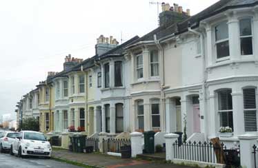
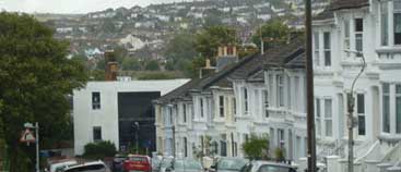
Most of Richmond Road was built in the 1880s. Those dwellings between the junction with Wakefield Road and the junction with Ashdown Road have semi basements since at the rear of these houses the gardens are at ground level, which falls away to Roundhill Crescent. The basements are protected by cast iron railings. The houses have painted rendered fronts with attractive canted bays which largely retain their original sash windows. Some of them have decorated pediments over their front doors, picked out in scrolled patterns.
One of the strips of land between the south side of Richmond Road and the north side of Roundhill Crescent was carefully planted from the early 1980s, winning its owners the national ‘Wildlife Garden of the Year’ award in 2003 and earning a six minute slot on BBC1’s coverage of the Chelsea Flower Show in May 2004. It continues to be home to dragonflies, lizards, slowworms, frogs, toads, butterflies, a huge variety of insects and many different birds.
Early in 2003, a temporary road closure was put in place separating the northern section of Richmond Road from the southern section at the junction of Mayo Road. The aim was to stop rat-running down Princes Road or Princes Crescent via Richmond Road to the Lewes Road Gyratory. In July 2003, the Council’s Transport Department submitted a report recommending that the closure be made permanent. This change has made parts of Round Hill safer and quieter, but Wakefield Road has gained much of the displaced traffic. In August 2004, Brighton and Hove City Council sought residents views: option 1 Wakefield Road one way up hill, option 2 no left turn at the junction of Wakefield Road with Upper Lewes Road, option 3 traffic calming through a series of road humps and option 4 do nothing. The do nothing option received the most support, so nothing was done.
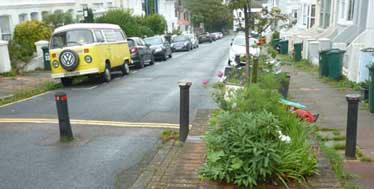
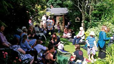
The northern end of Richmond Road has become a pleasant cul-de-sac. And as well as bollards, there are now three planters, a mountain ash tree, and a corner of roadway where residents can anchor community events.
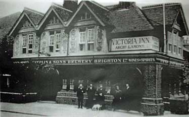
The junction of Richmond Road with Mayo Road was also the site of a greengrocers at no. 31A run by Miss A Willard in 1889 (Pike’s Directory) and then in 1891 (Pages Directory) the site of the Victoria Inn run by the same lady. The public house designed by Catt / Denman in 1887, briefly became the New Vic in the 1990s up until its closure in 2008. Two years later, it was converted into two houses.
Beyond the site of the former public house, the Edwardian houses on the west side cascade down the hill towards the north with views to the houses on the other side of the valley.
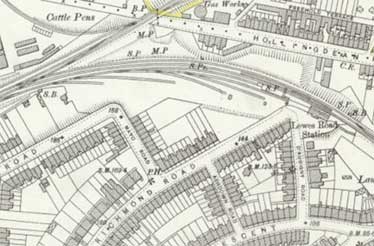
The OS Map of 1898 shows several sidings on the approach to Lewes Road Station, which had a thriving coal yard. There were several coal wharfs at the north end of Richmond Road, including Benfield’s, Lodder and Son’s, Pritchett’s, Rickett Smith & Co.and Correll and Co. After passenger services ceased on the Kemp Town branch line on 1st January 1933 and the coal yard moved over to the Richmond Road side. By the 1940s, the coal depot is shown as belonging to Brighton Equitable Co-operative Society Ltd and is named Lewes Road Station Wharf.
In place of the coal wharfs, there is now a number of mature trees, screening the conservation area from the Centenary Industrial Estate. The coal yard disappeared with the Sainsbury’s development around 1984.
The above picture, now Richmond House’s garden and car park, shows what was once the platform of Lewes Road Station. The station was also home to a pickle bottling factory. No. 128, opposite Lewes Road Station, having been a newsagent / tobacconist shop during the 1930s, became a Co-op fuel office. A metal ring on the wall was used for tying horses. Later (up until the mid 1960s) No. 128 became a sweet shop.
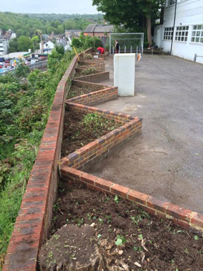
Richmond House itself was constructed in about 1957 and used initially for industrial purposes before being converted to office use in the mid 1990s. Since November 2015, it has been used as centre offering recovery-focused drug and alcohol support. Richmond house and its green embankment descending to Hughes Road (the industrial estate) falls within the setting of the conservation area.
Richmond Road extra
East Side runs from 2 to 130
West Side runs fron 1 to 53
Mayo Road is between 31 and 31A
Ashdown Road is between 94 & 96
When the houses were built
1878 116 - 128 Richmond Road.
1878 104 - 112 Richmond Road.
1879 86 - 102 Richmond Road.
1881 62 - 84 Richmond Road.
1881 16 - 20 Richmond Road.
1881 22 - 56 Richmond Road.
1881 33 - 45 Richmond Road.
1882 51, 53 & 55 Richmond Road.
1884 10, 12 & 14 Richmond Road.
1887 31A Richmond Road - The Victoria Inn
1888 47 Richmond Road (with integral garage or underpass)
1894 25 - 29 Richmond Road.
1895 58 & 60 Richmond Road.
1897 2 - 8 Richmond Road (built after Lennox Road proved unviable)
The coal wharfs
(south end of Richmond Rd)
History of James Corrall - Coal Merchant
| Houses | Coal Wharfs on opposite side of Richmond Road | |||
| 106 | LEWES ROAD STATION WHARF | |||
| 108 | Corral and Co. coal merchants | |||
| 110 | Lodder & Son, coal merchants | |||
| 112 | ||||
| 114-16 | ||||
| 118 | Ricket, Smith & Co Ltd coal merchants | |||
| 120 | ||||
| 122 | ||||
| 124 | Northern Coal Company | |||
| 126 | ||||
| 128 | ||||
| 130 empty | LEWES ROAD RAILWAY STATION |
1897 Map showing the coal sidings on the Kemptown branchline
The map can be dragged to reveal adjoining mapping in different directions.
- Notice that the Kemptown branchline leaves the Brighon to Lewes line at the points just after the Ditchling Road tunnel.
Watch the local freight train cross the points onto the Kemptown branchline on Video.
The signalbox - see picture - was at the far NE corner of the Carelet site.
First stop on the Kemptown branchline was LEWES ROAD STATION at the back of where Richmond House stands now. Notice the coal sidings located between the junction and the station, which provided access to the coal wharfs identified in the above list.
Round Hill history texts
Ashdown Road | Belton Road | Crescent Road | D'Aubigny Road | Ditchling Road | Lennox Passage (The Cats Creep) | Mayo Road | Princes Crescent | Princes Road | Richmond Road | Round Hill Crescent | Round Hill Road | Round Hill Street | Wakefield Road